▼
Advanced Options
?
Sort by:


popularity
similarity
?
Must Include:
?
Cannot Include:
?
Look For
▼
Sponsored Links
You're looking for other sites like :
 |
Map maker software for creating fully customizable interactive flash maps. StatPlanet also comes with over 250 world development indicators which ...
http://www.sacmeq.org/statplanet/
popularity:
maps
statistics
visualization
data
geography
interactive
map
software
socialstudies
mapping
|
new
search by a custom tag signature
|
|
For additional information about shaded relief I recommend that you visit this ... World Relief Map with Cross-blended Hypsometric Tints ...
similarity:
popularity:
maps
cartography
gis
visualization
mapping
geography
design
map
reference
relief
|
 |
Feb 11, 2011 to Miscellaneous | Post on Twitter. I got a chuckle out ... Feb 10, 2011 to Miscellaneous Visualization | Post on Twitter. As we all know, the iPad ...
similarity:
popularity:
visualization
data
statistics
infographics
design
blog
graphics
tools
web2.0
visualisation
|
|
|
Focuses on 18th and 19th century North and South American cartographic materials. Includes maps, atlases, globes, school geographies, and maritime charts.
similarity:
popularity:
maps
history
cartography
reference
geography
map
gis
art
archive
mapping
|
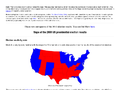 |
Book of cartograms: I have a new book of world cartograms entitled The Atlas of ... It's nothing to do with elections, but it contains more than 300 cartograms ...
similarity:
popularity:
politics
maps
visualization
election
statistics
voting
map
usa
2008
cartogram
|
|
|
TeleGeography's innovative approach to cartography distills complex data sets ... A detailed view of the telecommunications landscape in the Middle East. ...
similarity:
popularity:
maps
internet
visualization
map
network
mapping
geography
broadband
infographics
networking
|
|
|
Global community of data providers committed to making geographic content available and easy to publish online. Offers maps, satellite images, and demographic data.
similarity:
popularity:
gis
geography
maps
reference
mapping
data
geodata
tools
map
resources
|
|
|
No information avaiable
similarity:
popularity:
maps
geography
socialstudies
mapping
map
free
curriculum:socialstudies
mapcreation
map-making
resource
|
 |
About this Site. Welcome to Index Mundi, home of the Internet's most complete country profiles. ... January 26, 2009 Index Mundi welcomes its members. ...
similarity:
popularity:
statistics
reference
world
geography
maps
data
research
country
economics
database
|
 |
The GEO Data Portal online database holds more than 450 different variables, as national, subregional, regional and global statistics or as geospatial data sets ...
similarity:
popularity:
data
gis
maps
environment
statistics
geodata
database
geo
mapping
geography
|
|
|
Click on one of the two links below and you can download 3 animated maps – free ... PC ou Mac. Feel free to contact us if you need any further information. ...
similarity:
popularity:
history
maps
geography
visualization
reference
map
culture
education
tools
interactive
|
Sorting Results
- This slider determines how the matched sites are sorted.
- If you want to see the most popular sites that are somewhat related to your search, slide this more towards "popularity."
- If you want to see the sites that best matched your search, regardless of popularity, slide this towards "similarity."
Must Include Tags
- Matched sites will not be shown unless they have all of the tags on this list.
- This feature is useful for when you require a site to have been tagged as something.
- To add a tag to this list, click "add tag" or click on any tag in a result.
Must Not Include Tags
- Matched sites that have any tag on this list will not be shown.
- This feature is useful for filtering out results that have tags you are absolutely not interested in.
- To add a tag to this list, click "add tag" or click on any tag in a result.
Types of Results
- This option lets you specify the types of sites to show.
- If you want to only see domains (www.
.com), select "domains only." - If you want to only see articles (www.
.com/something/here), select "articles only." - If you don't care, or care so much about both, select "Both".
About The Results
 an example search result
How moreofit Searches
Each website has a unique tag signature -- a set of words
that users have described the website as. Moreofit searches
for websites that have similar tag signatures and displays the results.
1: Similarity
A site's "similarity" is determined by how well its tag signature matches the tag
signature that is being searched for. A 100% match means that it has the exact same
tags in the exact same order, while a 0% match means it has no tags in common.
2: Popularity
The popularity of a website is, well, pretty much self explanatory.
3: Tag Signature
The tag signatures show how a site is described. The deeper the color of the tag,
the more frequently the website is tagged as this. Tags underlined blue denote a tag
that is in common with the search's tag signature.