▼
Advanced Options
?
Sort by:


popularity
similarity
?
Must Include:
?
Cannot Include:
?
Look For
▼
Sponsored Links
You're looking for other sites like :
|
|
No information avaiable
http://traintimes.org.uk/map/tube/
popularity:
london
map
tube
travel
maps
mashup
underground
visualization
data
transport
|
new
search by a custom tag signature
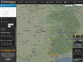 |
Flightradar24.com shows live aircraft traffic in the airspace above Europe.
similarity:
popularity:
flight
maps
travel
radar
tracking
map
air
visualization
live
flights
|
|
|
Book hotels online in the perfect location with SeeYourHotel.com - Browse a map with over 100000 hotels, see pictures, watch videos, look at StreetView.
similarity:
popularity:
travel
hotel
hotels
maps
search
map
visualization
vacation
mashup
tools
|
 |
No information avaiable
similarity:
popularity:
london
travel
uk
pass
tourism
londres
england
europe
guide
card
|
 |
Wikimapia is an online editable map - you can describe any place on Earth. ... All countries, USA, Canada, UK, Australia, New Zealand, Germany, Switzerland, ...
similarity:
popularity:
maps
wiki
map
google
googlemaps
web2.0
reference
mashup
travel
wikipedia
|
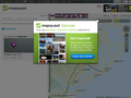 |
MapQuest provides interactive maps and driving directions for cities and towns worldwide. Also provides road trip planner, addresses, and phone number finder.
similarity:
popularity:
maps
travel
directions
reference
map
mapquest
search
tools_and_reference
tools
toolsandreference
|
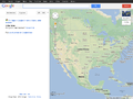 |
Online map service and location finder. Features dynamic, draggable maps, as well as satellite imagery by region.
similarity:
popularity:
maps
google
travel
map
reference
directions
search
tools
web2.0
mapas
|
|
|
Web-based mapping and searching: the geospatial web revolution, simplified ... Photos. Traffic. Videos. WiFi. Sign In. Directions. Email. Search. Toolbox ...
similarity:
popularity:
maps
atlas
map
web2.0
geography
ajax
mashup
microsoft
travel
reference
|
|
|
Allows users to see air routes that take advantage of the Earth's curviture to fly between cities, rather than follow what seem to be a straight line.
similarity:
popularity:
travel
maps
aviation
reference
geography
map
tools
mapping
airline
visualization
|
|
|
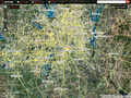
Printable subway maps for hundreds of world cities including those in Europe, North America, Australia, Africa, and Asia and the Middle East.
similarity:
popularity:
maps
travel
subway
metro
reference
map
transportation
world
visualization
tools
|
|
|
mapdango is a super map mashup that displays relevant information from Google Maps, Flickr, The New York Times, Wikipedia, Eventful, Google Weather and much more
similarity:
popularity:
maps
mashup
travel
web2.0
googlemaps
search
map
classifieds
google
mashups
|
Sorting Results
- This slider determines how the matched sites are sorted.
- If you want to see the most popular sites that are somewhat related to your search, slide this more towards "popularity."
- If you want to see the sites that best matched your search, regardless of popularity, slide this towards "similarity."
Must Include Tags
- Matched sites will not be shown unless they have all of the tags on this list.
- This feature is useful for when you require a site to have been tagged as something.
- To add a tag to this list, click "add tag" or click on any tag in a result.
Must Not Include Tags
- Matched sites that have any tag on this list will not be shown.
- This feature is useful for filtering out results that have tags you are absolutely not interested in.
- To add a tag to this list, click "add tag" or click on any tag in a result.
Types of Results
- This option lets you specify the types of sites to show.
- If you want to only see domains (www.
.com), select "domains only." - If you want to only see articles (www.
.com/something/here), select "articles only." - If you don't care, or care so much about both, select "Both".
About The Results
 an example search result
How moreofit Searches
Each website has a unique tag signature -- a set of words
that users have described the website as. Moreofit searches
for websites that have similar tag signatures and displays the results.
1: Similarity
A site's "similarity" is determined by how well its tag signature matches the tag
signature that is being searched for. A 100% match means that it has the exact same
tags in the exact same order, while a 0% match means it has no tags in common.
2: Popularity
The popularity of a website is, well, pretty much self explanatory.
3: Tag Signature
The tag signatures show how a site is described. The deeper the color of the tag,
the more frequently the website is tagged as this. Tags underlined blue denote a tag
that is in common with the search's tag signature.