▼
Advanced Options
?
Sort by:


popularity
similarity
?
Must Include:
?
Cannot Include:
?
Look For
▼
Sponsored Links
You're looking for other sites like Geonames:
 |
A worldwide geographical database with a search function, browsable maps, and downloadable data files available free under a Creative Commons attribution license.
http://www.geonames.org/
popularity:
maps
geocoding
database
geo
api
gis
geography
googlemaps
reference
map
|
new
search by a custom tag signature
|
|
Creates made-to-order world maps and cartographic images. Also offers travel books and clip arts of maps and flags.
similarity:
popularity:
maps
geography
atlas
reference
world
travel
map
education
socialstudies
resources
|
|
|
For additional information about shaded relief I recommend that you visit this ... World Relief Map with Cross-blended Hypsometric Tints ...
similarity:
popularity:
maps
cartography
gis
visualization
mapping
geography
design
map
reference
relief
|
 |
The UNEP/GRID-Arendal Maps and Graphics library contains hundreds of illustrations on themes related to environment and sustainable development, such as climate ...
similarity:
popularity:
maps
environment
geography
statistics
world
map
gis
graphics
reference
visualization
|
 |
The GEO Data Portal online database holds more than 450 different variables, as national, subregional, regional and global statistics or as geospatial data sets ...
similarity:
popularity:
data
gis
maps
environment
statistics
geodata
database
geo
mapping
geography
|
 |
MetaCarta allows users to identify and leverage geographic references in content. MetaCarta puts unstructured content on any map, making it geographically relevant.
similarity:
popularity:
maps
gis
mapping
geo
search
mashup
web2.0
visualization
map
software
|
 |
Online map service and location finder. Features dynamic, draggable maps, as well as satellite imagery by region.
similarity:
popularity:
maps
google
travel
map
reference
directions
search
tools
web2.0
mapas
|
|
|
Watch the OWS-6 Interactive Demonstration. Watch the AECOO-1 Video. Watch the CGDI Video and Demonstration. Watch the OWS-5 Interactive Demonstration ...
similarity:
popularity:
gis
geospatial
standards
opensource
mapping
maps
geo
map
ogc
reference
|
 |
Wikimapia is an online editable map - you can describe any place on Earth. ... All countries, USA, Canada, UK, Australia, New Zealand, Germany, Switzerland, ...
similarity:
popularity:
maps
wiki
map
google
googlemaps
web2.0
reference
mashup
travel
wikipedia
|
|
|
Allows designers, developers, and mapping geeks to place vectored Flash overlays on top of Google Maps.
similarity:
popularity:
flash
google
maps
googlemaps
api
programming
gis
mapping
vector
map
|
|
|
Location-to-URL reverse directory that allows users to find web sites by their proximity to a given physical location.
similarity:
popularity:
maps
geourl
web
geo
geography
search
blog
map
tools
url
|
Sorting Results
- This slider determines how the matched sites are sorted.
- If you want to see the most popular sites that are somewhat related to your search, slide this more towards "popularity."
- If you want to see the sites that best matched your search, regardless of popularity, slide this towards "similarity."
Must Include Tags
- Matched sites will not be shown unless they have all of the tags on this list.
- This feature is useful for when you require a site to have been tagged as something.
- To add a tag to this list, click "add tag" or click on any tag in a result.
Must Not Include Tags
- Matched sites that have any tag on this list will not be shown.
- This feature is useful for filtering out results that have tags you are absolutely not interested in.
- To add a tag to this list, click "add tag" or click on any tag in a result.
Types of Results
- This option lets you specify the types of sites to show.
- If you want to only see domains (www.
.com), select "domains only." - If you want to only see articles (www.
.com/something/here), select "articles only." - If you don't care, or care so much about both, select "Both".
About The Results
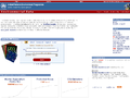
 an example search result
How moreofit Searches
Each website has a unique tag signature -- a set of words
that users have described the website as. Moreofit searches
for websites that have similar tag signatures and displays the results.
1: Similarity
A site's "similarity" is determined by how well its tag signature matches the tag
signature that is being searched for. A 100% match means that it has the exact same
tags in the exact same order, while a 0% match means it has no tags in common.
2: Popularity
The popularity of a website is, well, pretty much self explanatory.
3: Tag Signature
The tag signatures show how a site is described. The deeper the color of the tag,
the more frequently the website is tagged as this. Tags underlined blue denote a tag
that is in common with the search's tag signature.